
ILMS: the architect’s layout, live with every hold, booking and sale.
ILMS draws your project’s site plan to scale and wires every plot to its inventory record. Bring the architect’s DXF or PDF, confirm the scale once, link the plots — then sell from a plan that shows what is available right now, with the time it was last checked.
- DXF or PDF from your architect
- Scale confirmed by a person
- Facing · corner · road width
- Presentation mode with a 3-D view
- Live layout link on WhatsApp
- Professional Team & Custom
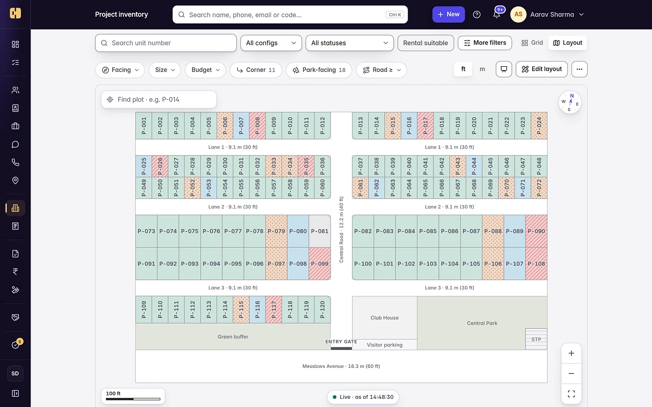
The layout PDF is out of date the day after a booking.
Every plotted project has a layout, and today it travels as a PDF in WhatsApp groups — the same file the day after a plot is booked, and the week after that. The plan and the inventory drift apart, and the sales floor pays for it.
Buyers shortlist plots that are gone
A forwarded layout cannot know that P-014 was booked on Saturday. The family arrives set on it, and the site visit starts with an apology.
Two people promise the same plot
When the plan in the site office and the sheet in the back office disagree, two agents can offer the same plot to two families on the same afternoon.
The premium lives in someone’s head
Corner, east-facing, park-facing, a 40-ft road — the facts behind a PLC sit in one salesperson’s memory, or in an Excel column somebody typed.
From the architect’s file to a live plan, in three steps.
No redrawing by hand. The plan comes from the drawing your architect already has, and a guide inside the editor explains each step in plain words.
-
01
Bring the architect’s file
A DXF, or a PDF exported from AutoCAD, comes in to scale with its plots, roads and numbers. A scanned plan or a photo becomes a tracing background. No drawing at all? Quick grid builds a plotted layout from rows, plot sizes and road widths.
-
02
Check the scale, link the plots
A person confirms the scale against one dimension printed on the plan, and marks north. Plots find their inventory records by number — “Plot 14” finds P-014 — and anything that does not match is listed for you, never guessed.
-
03
Publish, then share
Publishing checks the drawing first: errors block it, and each warning is acknowledged by name. Every publish is kept as a version with a note. Then open the Layout view, present it, or send a live link.
Got a PDF from your architect? Here is what happens to it.
Most layouts reach a builder as a PDF. What happens next depends on how that PDF was made — and ILMS tells you which kind you have, instead of pretending every PDF is the same.
It imports.
The lines, layers and plot numbers in a CAD-exported PDF come in the way a DXF does.
- Pick the page with the layout.
- Say which lines draw plots, which draw roads, and which are lettering.
- Confirm the scale against one printed dimension.
- Mark north, check the result, import.
You trace over it.
A scan is a picture, not lines, so it is never converted automatically. It becomes a crisp tracing background instead.
- Pick the page, and it is placed behind the drawing.
- Confirm the scale against one printed dimension.
- Trace the plots over it — or use quick grid for a regular layout.
- Number the plots and link them to inventory.
The scale is always confirmed
A plan printed “fit to page” is no longer 1:500. One printed dimension proves the scale, so no plot is stretched and no area is invented.
The file stays in your browser until you import
The PDF is read on your own screen. Nothing is uploaded until you choose to import it or trace over it, and nothing goes live until you publish.
DWG? Ask for DXF
DWG is a closed format and is not read. In AutoCAD, Save As → DXF takes your architect a minute, and a PDF exported from AutoCAD works too.
Every plot, measured from the drawing.
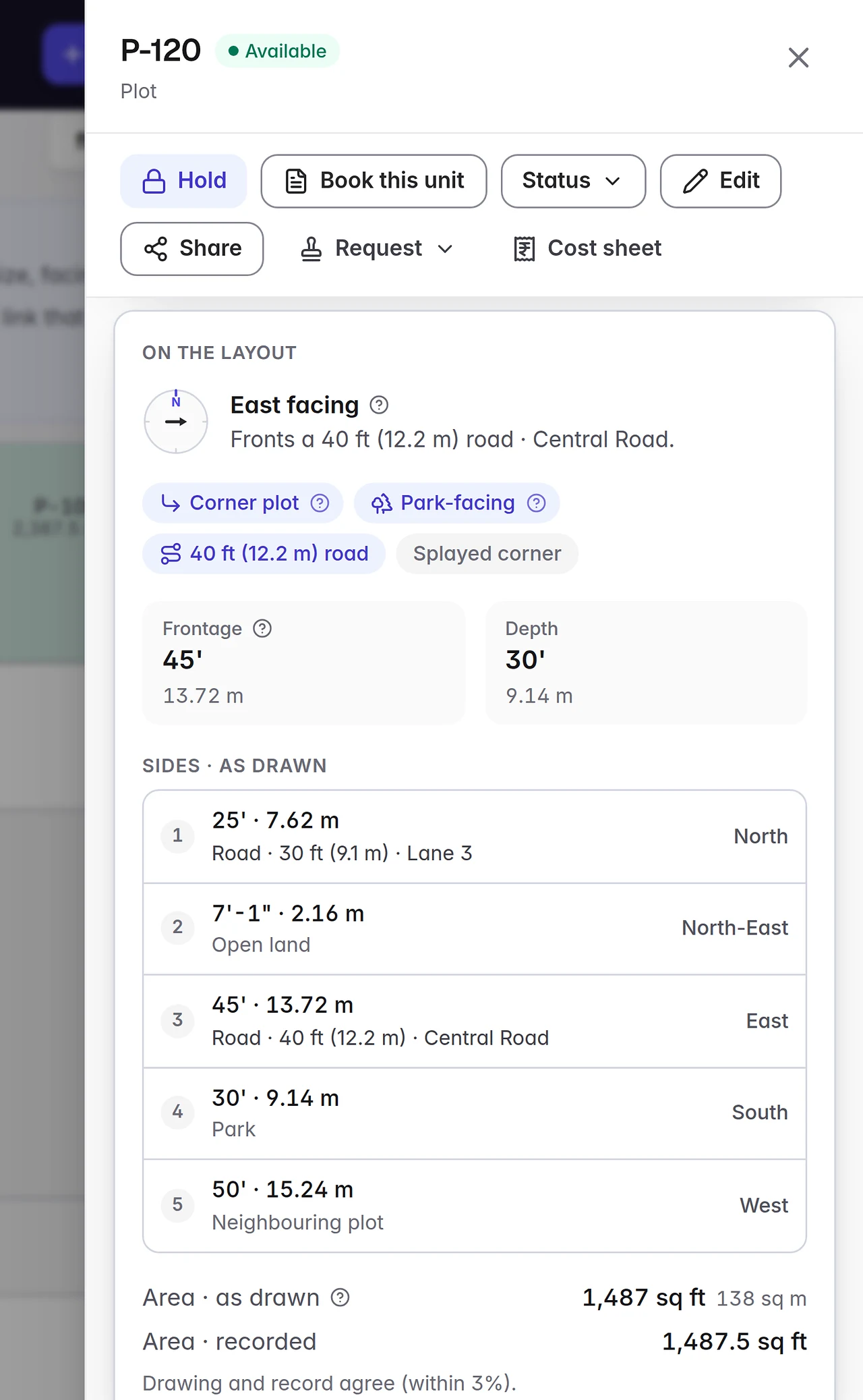
Once the plan is to scale and north is confirmed, each plot’s facts are worked out from the geometry — the things a buyer asks about first.
- Facing — the direction of the plot’s main road side, in eight directions. While north is unconfirmed, no facing is shown at all.
- Corner — roads on two sides that meet at an angle.
- Road width — the widest road the plot touches: 30 ft, 40 ft, 60 ft.
- Park-facing — a park beside the plot, or straight across its road.
- Frontage and depth — in feet and metres, side by side.
- Area as drawn — labelled “as drawn” and shown beside the recorded area, which stays the legal figure. A difference of more than 3% is flagged.
Apply the facts to inventory in one action: facing is filled in only where a unit record has none — never over what somebody typed — and corner and park-facing become tags your team can filter on. Every change lands in the audit log. Facts never set a price; they put the evidence for a PLC in front of whoever does.
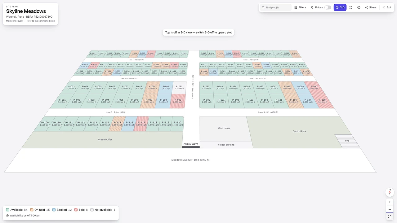
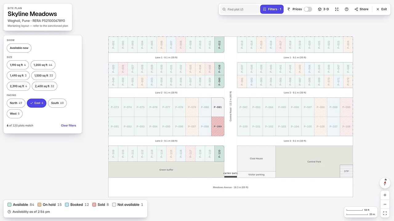
Put the plan on the site-office TV.
For walk-ins and site visits: the plan full screen, in large type, showing only what a customer may see — no holder names, no internal notes, and prices off until you switch them on.
- Filters a buyer understands. Size, facing and what is available now. A buyer asks for east-facing; tap East and the six east-facing plots stand out.
- Find any plot by number, and step from one plot to the next.
- A 3-D view tilts the plan like a model on a table — for the moment the family leans in.
- Availability you can trust on the day. The legend carries the time it was last checked, re-checked every 30 seconds, and turns amber if the connection drops instead of pretending.
- Share from the screen. Send the buyer a live link to the plan they were just shown.
Send the plan, not last week’s PDF.
Share the layout on WhatsApp as a link. It opens on the buyer’s phone as the plan itself, coloured by what is available now.
- Buyers see availability, not your back office. Available, on hold, booked, sold — never who holds a plot, or why.
- Prices are your choice. A link shows status only unless you switch prices on, and only someone who can edit inventory can do that.
- Tap a plot for its size, facing and road, and “Enquire about this plot”.
- You see when it was opened. Send it from a lead, and the lead’s record shows how often the link was opened, and when.
- Revoke it any time — it stops opening straight away. Links can also expire after 7, 30 or 90 days.
- Every shared plan carries the project’s RERA registration. A project without one cannot be shared.
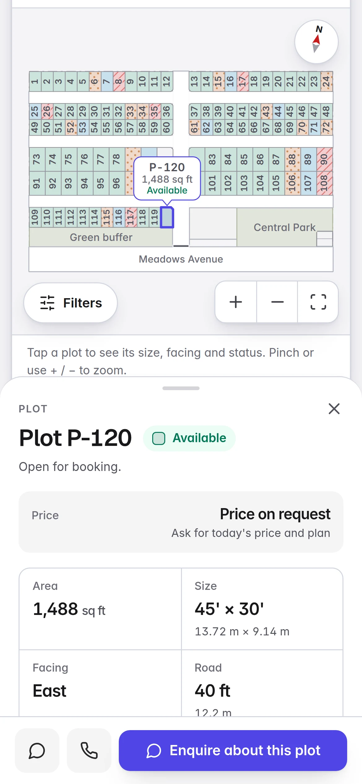
The field team carries the same plan.
In the Android app, the project’s site plan opens with the same live statuses. At the gate, with the family beside you:
- Tap a plot for its price, size on the plan, facing, road and area.
- Hold it with the same server-checked hold the unit screen uses.
- Share it with the buyer, from the site.
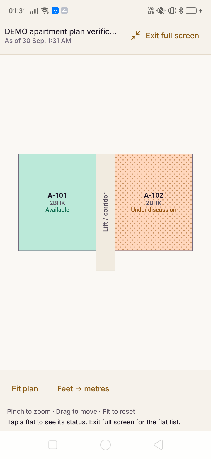
- Weak signal? The plans you opened recently are kept on the phone, labelled with their age — and after four hours the app asks you to refresh before quoting a price.
Made for the way plotted projects are sold here.
Sanctioned-plan numbering
Keep plot numbers exactly as the sanctioned layout prints them — DTCP, HMDA, BDA, PMRDA or your town-planning authority. Each published version says what it is: the sanctioned plan, with its authority and permit number, or a marketing layout. Presentation mode says which, on screen.
Feet and metres, side by side
Every side reads the way a plan prints it: 30′ · 9.14 m. Areas are in sq ft, and a buyer can switch the plot sheet to sq yd or sq m.
Roads carry their width
A 30-ft lane, a 40-ft road, a 60-ft main road: widths are part of the drawing, so frontage, corner and facing are worked out from them rather than typed.
Vastu starts with north
North is confirmed once for the layout, so every plot’s facing is worked out, not guessed. With north unconfirmed, no facing is shown — “I could not tell” is never east.
PLC with evidence
Corner and park-facing become tags on the unit record, so the premium your team quotes points back to the drawing instead of to memory.
Phases
A plan belongs to one project, so a phase set up as its own project gets its own plan and its own live link.
Included in Professional Team and Custom. Not included in Solo.
ILMS is part of Professional Team and Custom. Solo keeps everything else it has today — inventory, holds, cost sheets, and brochure and document share links, which stay on every plan.
Changing plans never deletes a drawing. If a workspace leaves the team plans, its layouts stay stored and come back on upgrade; its live layout links show “unavailable” until then.
- SoloNot included
- Professional TeamIncluded
- CustomIncluded
Can ILMS read a DWG file?
No. DWG is a closed format, so ILMS reads the DXF that AutoCAD saves from it — ask your architect for Save As → DXF, which takes a minute. A PDF exported from AutoCAD works too.
What if all we have is a scanned PDF or a photo of the layout?
It becomes a tracing background. You draw the plots over it, or use quick grid for a regular layout, and confirm the scale against a dimension printed on the plan. A scan is traced, never converted automatically.
Our layout PDF has several pages. Which one is used?
You choose. Each page is shown with its sheet size and whether it looks like a drawing or a scan, and the page with the most linework is picked for you to start with.
The layout was revised. What happens to the old one?
Publish the new drawing as a new version, with a note. Every version is kept with who published it and when, and an older one can be restored into the draft. A plot with a live hold or booking whose shape changed is flagged before you publish.
We launch in phases. Can each phase have its own plan?
Yes, when each phase is set up as its own project: a plan belongs to one project and gets its own live link. A very large drawing is best split by phase anyway.
Can the plan carry Hindi or Marathi text?
Labels are ordinary text, so road and landmark names can be written in Devanagari, and Unicode text in a DXF comes through as text. Keep plot numbers exactly as the sanctioned plan prints them — that is how each plot finds its inventory record. Lettering that a PDF draws as lines instead of text cannot be read as words; number those plots with the numbering tool.
Who can edit the layout?
People whose role can edit inventory. One person edits at a time — the others see who — and every publish is recorded as a version. Anyone who can view the project’s inventory can open the Layout view.
See a plotted project live on the plan.
A demo walks through the Layout view, presentation mode with its 3-D view, plot facts and a live layout link, in a seeded demo workspace. Your own workspace is set up after payment is received.